We finally bid farewell to Wrightsville Beach on Friday morning and began our journey down Cape Fear. And Cape Fear was not fearsome because we waited for good conditions (and got to enjoy that one day of vacation as per blog entry Day 25). Once again, the sailor adages were correct: Never sail to a schedule.
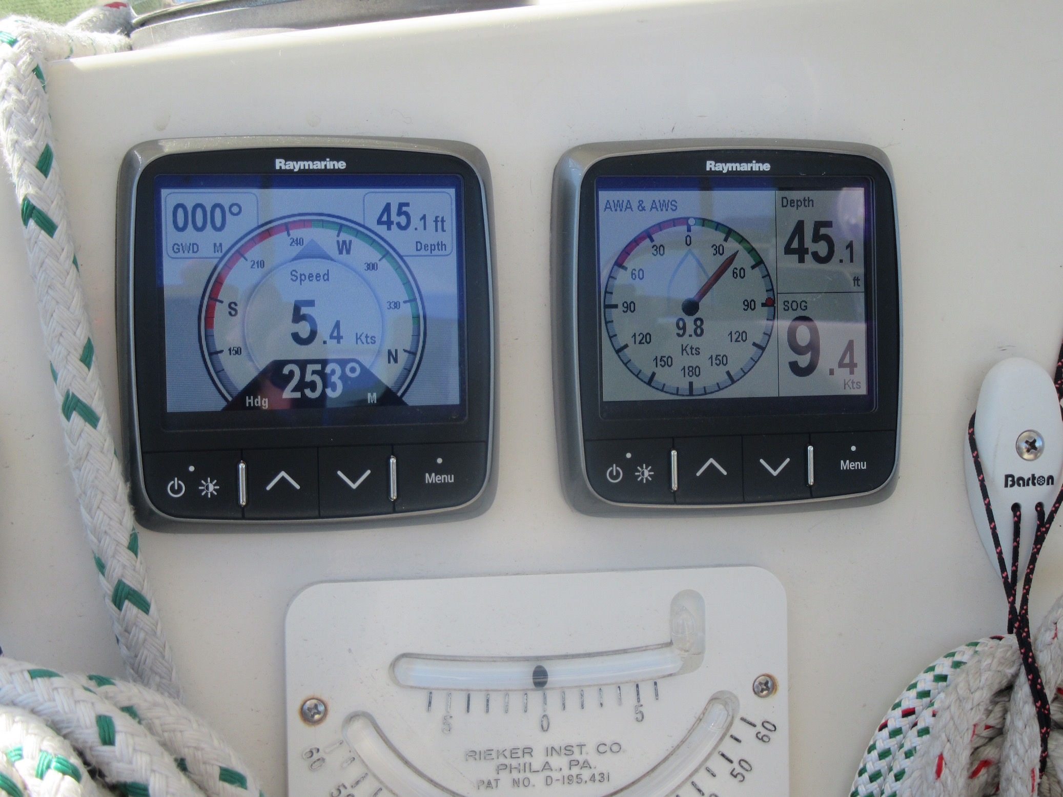
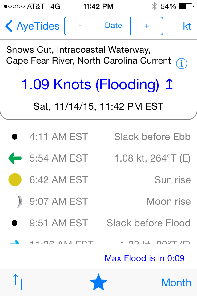
We are now entering the part of the ICW where tides and currents get added to the weather forecasts in determining optimal conditions. For those of us who have spent our sailing years on the Chesapeake Bay, we really haven’t experienced tides and currents. I’m learning that fast! Except for storm surges, our typical tidal difference in the Chesapeake is about 18 inches. And perhaps we can pick up one knot of current here or there, or get slowed down by opposing current of a knot or so.
But in North Carolina, we began to experience a few of feet of tidal range, and some current. And that’s nothing compared to what awaits us in South Carolina and Georgia. And all of this is vitally important to keeping our floating home in one piece. It’s sort of like an obstacle course on steroids. Or maybe a video game, where you don’t know what’s lurking behind the next bend. Here are some examples from just the last two days.
Shoaling warnings: On the ICW, we stay on high alert to “ICW Trouble Spots” as described by Captains Mark and Diana Doyle in their On the Water Chartguides, aka our cockpit bibles. This includes shoaling— places where the charted depths may be less than previously recorded due to currents, recent storms, and natural changes. Usually, new markers in the water (red nuns or green cans) have been added to help guide boaters, and these are typically more up-to-date than our Raymarine charts. Even better, we have Active Captain on our Garmin charts, which are displayed at the helm on an iPad. So low tech and high tech methods converge to keep us informed to avoid running aground.
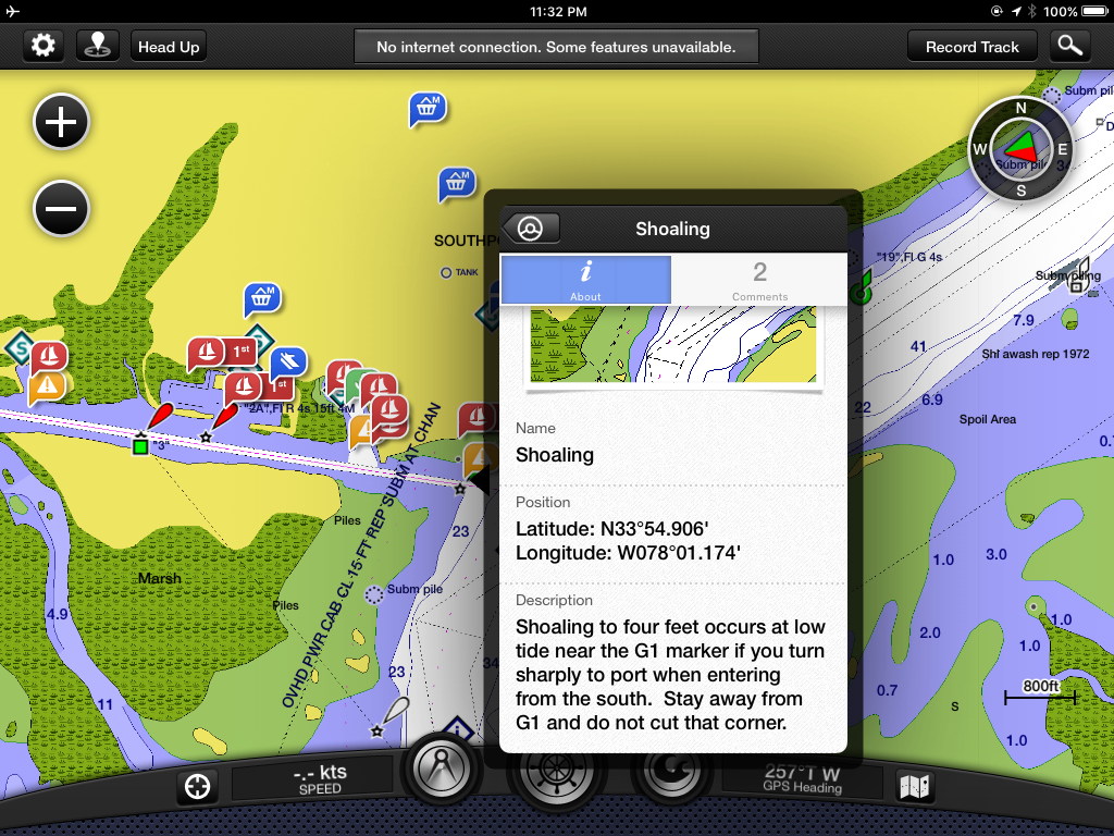
Our boat draws 5’6” (depth from waterline to bottom of our keel) so we need about six feet of water to pass safely. And frankly, we prefer not cutting it too close, so we really like to have at least 12-18 inches to spare, for obvious reasons. If we use the rising tides, and the greater tidal ranges, and plan it carefully, we can get that extra insurance and breathe more easily through the trouble spots.
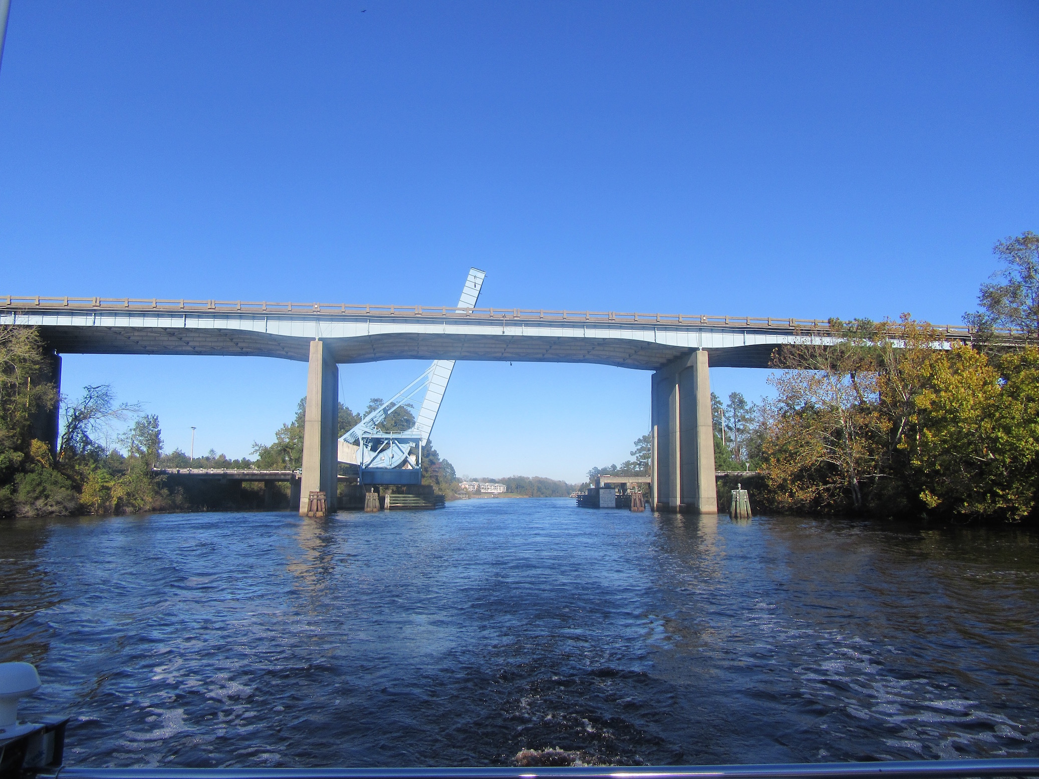
Bridge heights: While we might benefit from rising tides to avoid running aground, the higher water then affects the ability for sailboats with tall masts to pass safely under a bridge. Yep, a good thing can quickly become a bad thing. Fortunately for us, our mast is 59’ plus an antenna, which puts us at 62.5’ (we think). So we haven’t been sweating it too much. But we witnessed two catamarans hit the underside of the Route 544 Bridge today. We had been following them most of the day, and the three of us were actually between the Socastee swing bridge (behind us) and the Route 544 Bridge (in front of us) when both boats slowed to a snail’s pace. I was at the helm and had to slow and then reverse to avoid hitting them. We were puzzled about the slowing until we watched their masts graze the bridge’s underbelly. They survived, and we were glad our mast hasn’t been challenging the posted ICW heights, rumored to be at 65’—yikes!
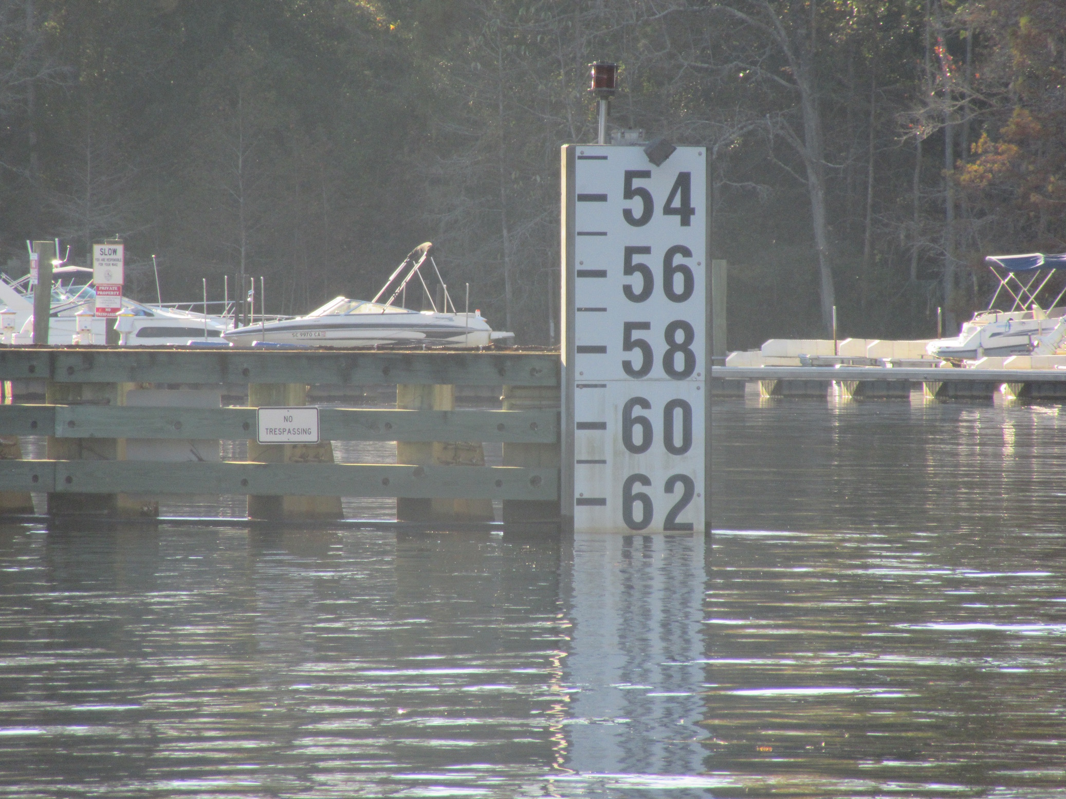
In case you are wondering, most bridges have “sign boards” at the base that estimate the height of the bridge. The height of the Route 544 Bridge is supposed to be 65’ at mean high water. But today it was indeed lower than that, as shown on the photo Dudley took after we passed!
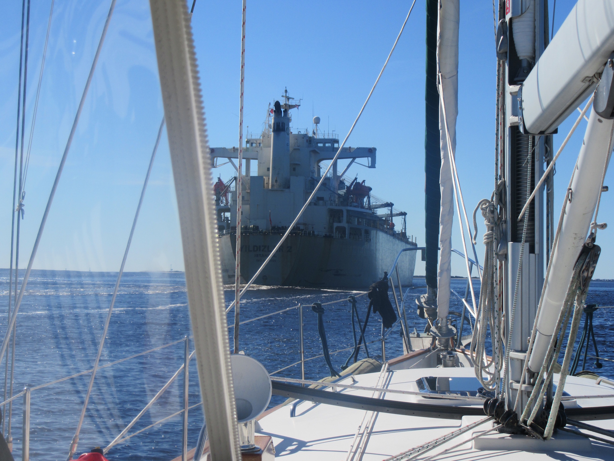
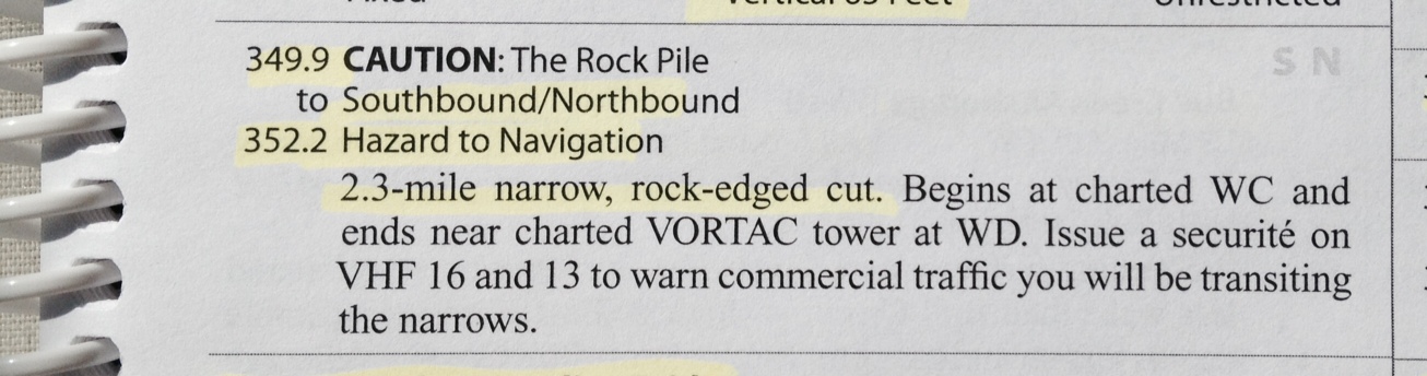
Rocks: Yep, rocks! I had been postponing my worries about rocky bottoms until we approach the coral bottoms in the Bahamas. But apparently rocky bottoms exist on the ICW. The cockpit bibles warned of a “19-mile narrow, rock-edged canal…Mariners should use extreme caution to avoid grounding in this area.” Roger that! There’s one stretch, called The Rock Pile, that is especially narrow and “the rockiest.” The guides suggested that we broadcast a securité warning on VHF on two channels to warn commercial traffic that we would be transiting. We did! And I was told by Captain Tyler in a text the previous evening that The Rock Pile is NO place to be polite—he advised us to stay in the middle, and not move over for anybody, period. Fortunately, no one tred to pass us, southbound or northbound, so we happily survived the Rock Pile. I brought out the Reese’s to celebrate!
In addition to the three main obstacles above, we’ve been warned of wrecked boats, strong currents, submerged pilings, and other obstructions. And then there’s the “Navaids Reverse” warnings, where the navigational aids of “red right returning” and greens on the left actually reverse so that red is on the left and green is on the right. Not something you want to confuse!
It really did feel like an obstacle course these last few days. But hey—we made it to another state, without running aground, hitting a bridge, or being dashed upon rocky ledges! We’re in South Carolina!
Hi,
REALLY enjoying your web posts! Following you on Marinetraffic, but it frequently shows you with AIS turned off. I guess that is when you have turned off all instruments. When/where are you going “outside” – or aren’t you?
Nolan (True North)
Yes, we are frustrated with the AIS lack of accuracy as well. We do think that turning off the instruments when we dock or anchor is adding to the lack of timeliness of reporting. But that can’t be the whole story. We just anchored in the South Santee River at 2 pm today (Sunday, Nov 15) and left the instruments on while trying to stream the last half of the Ravens game (ugh-sadly just heard the Ravens lose). I just checked and MarineTraffic still has us in North Carolina! And we’ve been in SC for over 24 hours. So for now, don’t trust the AIS position—but it’s still cool you are following us!
As for the “outside”—we aren’t sure yet. Captain D is growing weary of the ICW trouble spots so hang on, we may just hit the ocean. Stay tuned.
OMG! That obstacle course you described takes space planning and management to another whole other level!! LOL! You guys are sure on a challenging adventure. Knowing you Cheryl, there is no doubt you are up to the challenge. Love your blog. Enjoy every day and be safe.
Love, Joyce
Thanks Joyce! I was a bit concerned that this particular post would be too technical but I thought some people would like to know a few of the challenges. Glad to hear you appreciated it, and wisely observed the correlation to design and project management. LOL! Thanks for following along!
The Ditch ! It’s a real (rhymes with rich) !!!
It’s everything everyone said it would be! And by the way, hope you liked your role in our “About Us” page. You are certainly the Right Honorable Reverend Captain Phil!
Wow, I knew sailing was involved, but had NO idea! Great job! Keep a level head and a wary eye and other such nautical speak! ?
Roger that! Glad you enjoyed that post. Seemed like the right time to share some of the more technical aspects of this adventure. Thanks for following our journey!
Enjoyed meeting you today at church. Happy to take you back to your boat. Beautiful boat and so well equipped. Will enjoy following your adventure. Nice to meet Dudley also. Good sailing to both of you!
Thank you Charlotte! I so enjoyed our brief time together. Thanks for the ride and for following our journey. We’ll be back!
Hi Cheryl, We just got up to date on your site. We are enjoying your journey and the information you have provided. How did you set up this blog? There are lots of options out there and we like the way yours is laid out. Kit
Glad you are enjoying the blog. Ours is a WordPress blog, and I had a friend help me set it up. WordPress has lots of templates. And they have great instructional videos. So I suggest you visit their website and play around a bit. Thanks for following our journey!